Wendell H. Ford Airport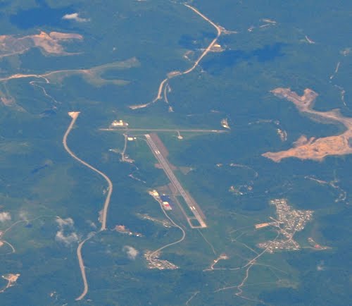
1300 Terminal Road
Chavies, KY
(606) 439-5140
Flying in to Hazard?
FAA INFORMATION EFFECTIVE 05 JANUARY 2017
Location
| FAA Identifier: |
CPF |
| Lat/Long: |
37-23-14.5000N / 083-15-41.8000W
37-23.241667N / 083-15.696667W
37.3873611 / -83.2616111
(estimated) |
| Elevation: |
1256.4 ft. / 383.0 m (surveyed) |
| Variation: |
06W (2010) |
| From city: |
10 miles NW of HAZARD, KY |
| Time zone: |
UTC -5 (UTC -4 during Daylight Saving Time) |
| Zip code: |
41367 |
Airport Operations
| Airport use: |
Open to the public |
| Activation date: |
11/1983 |
| Sectional chart: |
CINCINNATI |
| Control tower: |
no |
| ARTCC: |
INDIANAPOLIS CENTER |
| FSS: |
LOUISVILLE FLIGHT SERVICE STATION |
| NOTAMs facility: |
LOU (NOTAM-D service available) |
| Attendance: |
0800-DUSK |
| Wind indicator: |
lighted |
| Segmented circle: |
yes |
| Lights: |
ACTVT MIRL RY 14/32, REIL RYS 14 & 32 AND PAPI RYS 14 & 32 - CTAF. |
| Beacon: |
white-green (lighted land airport)
Operates sunset to sunrise. |
| Landing fee: |
yes, RAMP FEES. |
Airport Communications
| CTAF/UNICOM: |
122.7 |
| WX AWOS-3: |
119.025 (606-435-2452) |
| WX ASOS at JKL (13 nm N): |
118.375 (606-666-2794) |
- APCH/DEP SVC PRVDD BY INDIANAPOLIS ARTCC ON FREQS 126.575/257.850 (LYNCH RCAG).
Nearby radio navigation aids
| VOR radial/distance |
|
VOR name |
|
Freq |
|
Var |
|---|
| AZQ at field |
|
HAZARD VOR/DME |
|
111.20 |
|
04W |
Airport Services
| Fuel available: |
100LL JET-A+ |
| Parking: |
hangars and tiedowns |
| Airframe service: |
MINOR |
| Powerplant service: |
MINOR |
| Bottled oxygen: |
NONE |
| Bulk oxygen: |
NONE |
Runway Information
Runway 14/32
| Dimensions: |
5499 x 100 ft. / 1676 x 30 m |
| Surface: |
asphalt, in good condition |
| Weight bearing capacity: |
|
| Runway edge lights: |
medium intensity |
|
RUNWAY 14 |
|
RUNWAY 32 |
| Latitude: |
37-23.428628N |
|
37-22.746065N |
| Longitude: |
083-15.949418W |
|
083-15.202738W |
| Elevation: |
1243.0 ft. |
|
1256.4 ft. |
| Traffic pattern: |
left |
|
left |
| Runway heading: |
145 magnetic, 139 true |
|
325 magnetic, 319 true |
| Markings: |
nonprecision, in good condition |
|
nonprecision, in good condition |
| Visual slope indicator: |
4-light PAPI on left (3.00 degrees glide path) |
|
4-light PAPI on left (4.00 degrees glide path)
UNUSBL BYD 2.5 NM. UNUSBL BYD 7 DEG RIGHT OF FINAL & BYD 5 DEG LEFT OF FINAL. |
| Runway end identifier lights: |
yes |
|
yes |
| Touchdown point: |
yes, no lights |
|
yes, no lights |
| Instrument approach: |
LOCALIZER |
|
|
| Obstructions: |
100 ft. trees, 4293 ft. from runway, 250 ft. left of centerline, 40:1 slope to clear |
|
99 ft. trees, 2049 ft. from runway, 123 ft. left of centerline, 18:1 slope to clear |
Runway 6/24
| Dimensions: |
3246 x 60 ft. / 989 x 18 m |
| Surface: |
asphalt, in good condition |
| Weight bearing capacity: |
|
|
RUNWAY 6 |
|
RUNWAY 24 |
| Latitude: |
37-23.366855N |
|
37-23.639830N |
| Longitude: |
083-16.187240W |
|
083-15.610900W |
| Elevation: |
1242.3 ft. |
|
1242.5 ft. |
| Traffic pattern: |
left |
|
left |
| Runway heading: |
065 magnetic, 059 true |
|
245 magnetic, 239 true |
| Displaced threshold: |
200 ft.
ARPT HAS PERMANENTLY REMOVED ALL LIGHTING FROM RY 6/24. |
|
271 ft. |
| Markings: |
basic, in good condition |
|
basic, in good condition |
| Touchdown point: |
yes, no lights |
|
yes, no lights |
Airport Ownership and Management from official FAA records
| Ownership: |
Publicly-owned |
| Owner: |
HAZARD-PERRY COUNTY BOARD
P.O. BOX 420
HAZARD, KY 41702
Phone 606-436-3171 |
| Manager: |
JEFF HYLTON
PO BOX 2346
HAZARD, KY 41701
Phone 606-439-5140
AIRPORT PHYSICAL ADDRESS: 1300 WENDELL FORD TERMINAL ROAD CHAVIES,KY 41727 |
Airport Operational Statistics
| Aircraft based on the field: |
|
32 |
| Single engine airplanes: |
|
13 |
| Multi engine airplanes: |
|
8 |
| Jet airplanes: |
|
6 |
| Helicopters: |
|
5 |
|
|
 |
|
| Aircraft operations: avg 28/day * |
| 41% |
transient general aviation |
| 38% |
local general aviation |
| 13% |
air taxi |
| 8% |
military |
| * for 12-month period ending 27 August 2015 | |
Additional Remarks
| - |
RY 6/24 CLSD DAILY SS-SR |
| - |
RY 6 HAS A 300 FT DROP OFF SW END. |
| - |
RY 24 HAS A 300 FT DROP OFF NE END. |
| A58-24 |
NMRS CLOSE IN OBSTNS IN APCH SFC. |
| A58-06 |
NMRS CLOSE IN OBSTNS IN APCH SFC. |
Instrument Procedures
NOTE: All procedures below are presented as PDF files. If you need a reader for these files, you should download the free Adobe Reader.NOT FOR NAVIGATION. Please procure official charts for flight.
FAA instrument procedures published for use between 2 February 2017 at 0901Z and 2 March 2017 at 0900Z.
IAPs - Instrument Approach Procedures |
|---|
| RNAV (GPS) RWY 14 |
|
download (226KB) |
| RNAV (GPS) RWY 32 |
|
download (219KB) |
| LOC/DME RWY 14 |
|
download (232KB) |
| VOR/DME RWY 14 |
|
download (202KB) |
| NOTE: Special Take-Off Minimums/Departure Procedures apply |
|
download (126KB) |
Other nearby airports with instrument procedures:
KJKL - Julian Carroll Airport (13 nm N)
I35 - Tucker-Guthrie Memorial Airport (32 nm S)
KPBX - Pike County Airport-Hatcher Field (35 nm E)
KSJS - Big Sandy Regional Airport (37 nm NE)
KLNP - Lonesome Pine Airport (42 nm SE)
| Aerial photo |
|---|
WARNING: Photo may not be current or correct

Photo taken 30-Dec-2016
Looking North
|
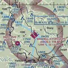
| Sectional chart |
|---|
| NOTAMs |
|---|
NOTAMs are issued by the DoD/FAA and will open in a separate window not controlled by AirNav.
|
|
All information supplied by: